Tenkasi District Overview
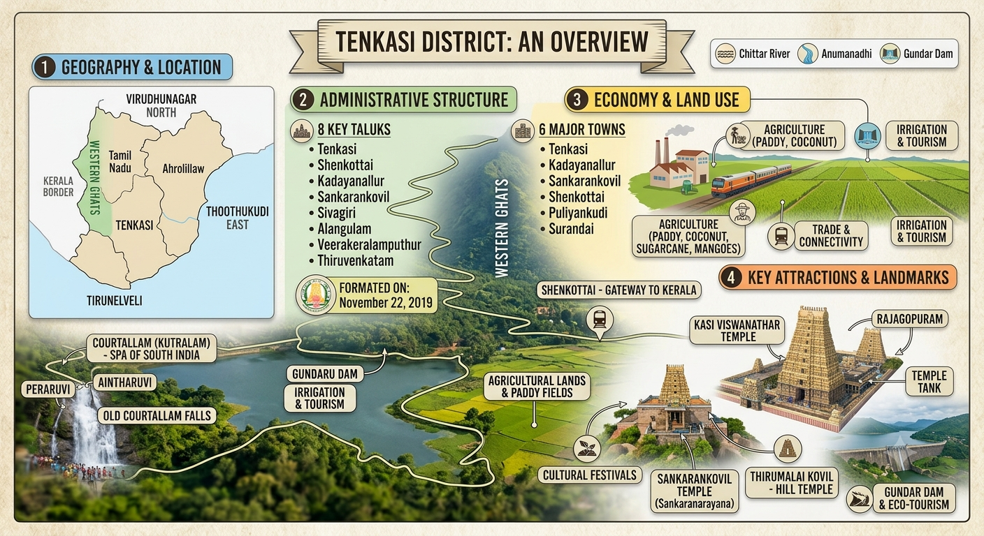
Tenkasi District, officially created on November 22, 2019, through the bifurcation of Tirunelveli district, serves as a vital administrative and cultural region in southern Tamil Nadu. Bordered by the Western Ghats to the west, the district covers a total geographical area of 2,882.43 square kilometers, with over 78 percent of its land mass dedicated to rural and agricultural tracts alongside 440 square kilometers of protected forest area. Headquartered in Tenkasi town, the district comprises two revenue divisions, eight taluks, six municipalities, and 580 revenue villages. Demographically, Tenkasi is home to a projected population of approximately 1.6 million people, maintaining a high literacy rate of nearly 80 percent and a favorable sex ratio of over 1,020 females per 1,000 males. Economically, the district is predominantly agrarian, with over 65 percent of the workforce engaged in farming and allied activities. It is renowned for high-yield cultivation of paddy, sugarcane, pulses, and lemons—notably earning Puliyangudi the title of Lemon City—complemented by active handloom, matchbox manufacturing, and wind energy sectors.Historically known as the seat of the late Pandyan dynasty, Tenkasi translates to Kasi of the South, named after the iconic 15th-century Kasi Viswanathar Temple constructed by King Arikesari Parakrama Pandya. Modern Tenkasi is equally famous for its vibrant eco-tourism, centered around the Courtallam waterfalls, seasonal monsoon retreats, and key border transit routes connecting Tamil Nadu to Kerala via Shenkottai.Tenkasi continues to expand its infrastructural footprint through direct connectivity via National Highways NH 744 and NH 208, linking major industrial hubs in Tamil Nadu to commercial coastal centers in Kerala. The district’s economy is increasingly diversifying, with traditional handloom weaving and match factories receiving modern industrial support alongside growing renewable energy investments in wind and solar power. Supported by a robust network of financial institutions and local cooperatives, the district balances its rich agrarian traditions with steady urbanization and community infrastructure developments.This unique geography fuels the continuous flow of major water channels like the Chittar and Anumanadhi rivers, filling local reservoirs like Gundar and Karupanadhi to sustain agricultural irrigation throughout the year.
Cities and Towns
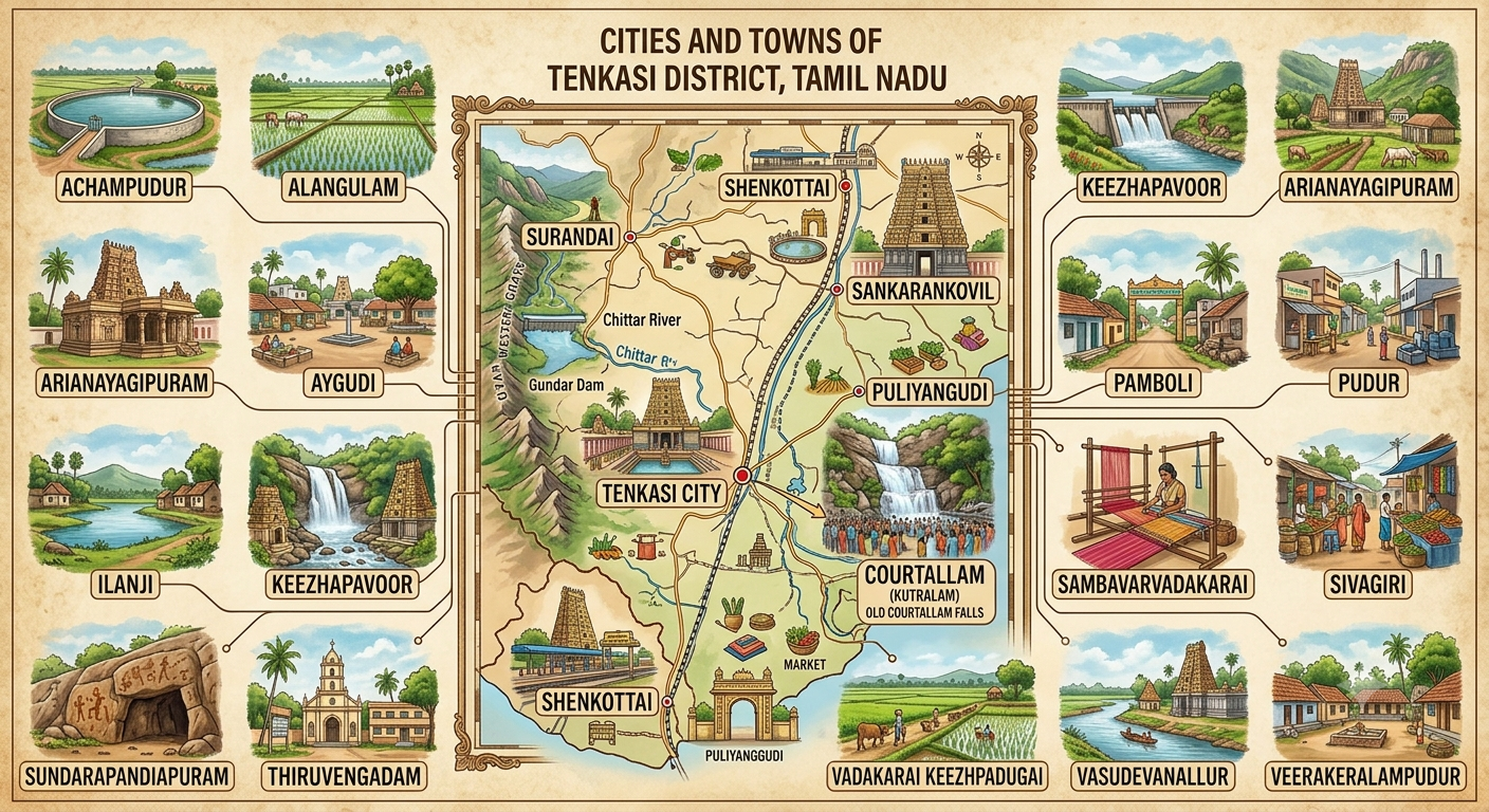
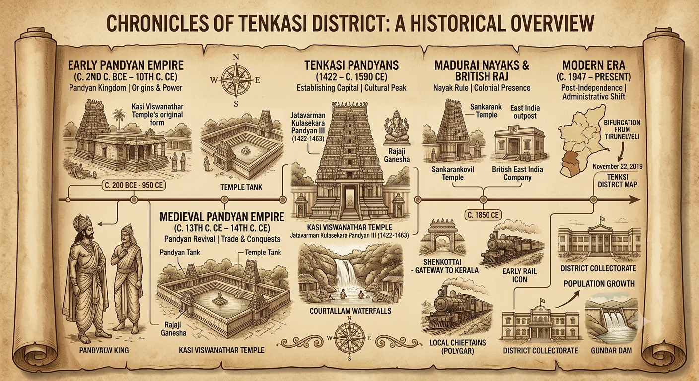
Tenkasi District features a dynamic network of urban centers and historical market towns, anchored by Tenkasi town as the administrative and commercial heart. Positioned around the historic Kasi Viswanathar Temple, Tenkasi town acts as the principal hub for regional commerce, transport, and public governance. Major urban centers like Sankarankovil and Kadayanallur serve as critical socio-economic pillars—Sankarankovil is renowned for its cultural heritage and thriving textile trading markets, while Kadayanallur forms one of the most populous municipal hubs in the district, active in trade, agriculture, and local entrepreneurship. Extending toward the Western Ghats mountain pass, Shenkottai functions as a crucial gateway town connecting Tamil Nadu with Kerala, historically serving as a major rail and road transit node. Prominent municipal towns like Puliyangudi have earned regional fame as agricultural powerhouses—dubbed the “Lemon City” due to its extensive citrus markets—while towns such as Alangulam and Surandai serve as rapidly growing commercial crossroads for surrounding agrarian villages. Together with scenic township belts like Courtallam, these towns create an interconnected network that balances urban trade with rural accessibility across the district.The story of Tenkasi is deeply intertwined with the medieval and late Pandyan dynasties. When northern political shifts forced the Pandyan rulers southwards in the 15th century, King Arikesari Parakrama Pandya established Tenkasi as his royal capital, commissioning the architectural masterpiece of the Kasi Viswanathar Temple. This historical era transformed the region from a collection of forest settlements into a flourishing center of Tamil art, literature, and temple architecture. Over the centuries, control transitioned through the Madurai Nayaks and the regional Poligar system before integration into the British East India Company’s administrative framework.
Tenkasi District Population
Tenkasi District Statistic
| Category | Key Parameter / Unit | Data & Specifics |
| Basic Profile | State / Formation Date | Tamil Nadu | November 22, 2019 (Bifurcated from Tirunelveli) |
| District Headquarters | Tenkasi Town | |
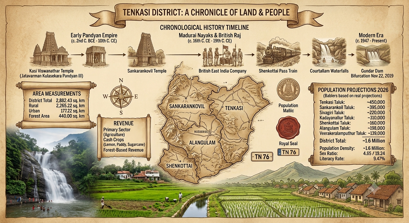
| Total Land Area | 2,882.43 sq. km (Rural: 2,265.22 sq. km | Urban: 177.22 sq. km) | |
| Vehicle Registrations | TN-76 (Tenkasi), TN-79 (Sankarankoil) | |
| Demographics | Total Population (2011 Base) | 1,420,064 (697,635 Males | 743,160 Females) |
| Projected 2026 Population | ~1,597,570 (~1.60 Million) | |
| Population Density | ~493 / km² (2011) | ~554 / km² (2026 Est.) | |
| Sex Ratio | 1,065 females per 1,000 males (2011 Base) | |
| Literacy Rate | 73.8% (2011 Base) | ~79.5% (2026 Est.) | |
| Registered Electors | 1,361,441 voters | |
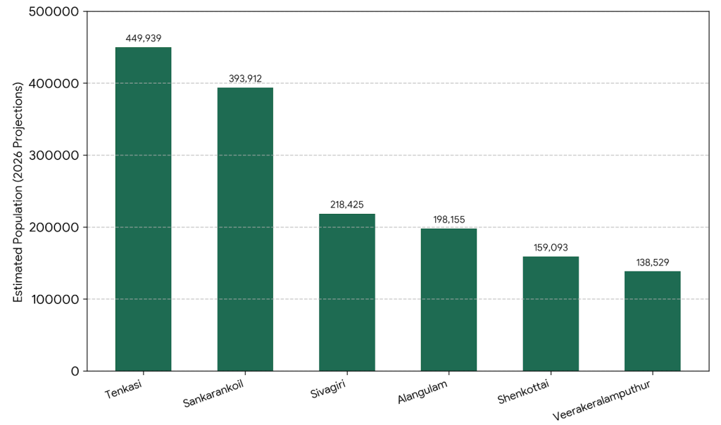
| 2026 Estimated Taluk Population | 1. Tenkasi Taluk | ~449,939 |
| 2. Sankarankoil Taluk | ~393,912 | |
| 3. Sivagiri Taluk | ~218,425 | |
| 4. Alangulam Taluk | ~198,155 | |
| 5. Shenkottai Taluk | ~159,093 | |
| 6. Veerakeralamputhur Taluk | ~138,529 | |
| Administrative Units | Revenue Divisions (2) | Tenkasi, Sankarankovil |
| Taluks (8) | Tenkasi, Sankarankovil, Shenkottai, Sivagiri, Kadayanallur, Alangulam, Veerakeralamputhur, Thiruvenkatam | |
| Municipalities (6) | Tenkasi, Kadayanallur, Sankarankovil, Shenkottai, Puliyankudi, Surandai | |
| Panchayat Unions & Villages | 10 Blocks | 17 Town Panchayats | 221 Village Panchayats | 580 Revenue Villages | |
| Electoral Setup | Lok Sabha Constituency | Tenkasi SC Constituency |
| Assembly Constituencies (5) | Sankarankovil (SC), Vasudevanallur (SC), Kadayanallur, Tenkasi, Alangulam | |
| Geography & Attractions | Major Rivers & Dams | Rivers: Chittar, Anumanadhi | Dams: Gundar, Adavinayinar, Karupanadhi, Ramanadhi |
| Key Tourist Destinations | Courtallam Waterfalls (Peraruvi, Aintharuvi), Kasi Viswanathar Temple, Sankarankovil Temple, Thirumalai Kovil |
Area Measurement
| Category / Geographic Division | Area (sq. km) | Area (sq. miles) | Percentage Share | Notes & Details |
| Entire Tenkasi District | 2,882.43 | 1,112.91 | 100.0% | Official total land area |
| Rural Area | 2,265.22 | 874.61 | 78.59% | Agricultural and village panchayat land |
| Urban Area | 177.22 | 68.42 | 6.15% | Covers 6 Municipalities and 17 Town Panchayats |
| Forest Area | 440.00 | 169.88 | 15.26% | Reserve forests along Western Ghats foothills |
| Sivagiri Taluk | ~750.00 | ~289.58 | ~26.02% | Largest taluk by area (includes forest tracts) |
| Tenkasi Taluk | ~480.00 | ~185.33 | ~16.65% | Administrative hub & headquarters |
| Sankarankoil Taluk | ~420.00 | ~162.16 | ~14.57% | Major northern sub-division |
| Alangulam Taluk | ~350.00 | ~135.14 | ~12.14% | Eastern agricultural belt |
| Kadayanallur Taluk | ~310.00 | ~119.69 | ~10.75% | Central valley region |
| Shenkottai Taluk | ~230.00 | ~88.80 | ~7.98% | Western Ghats border town area |
| Veerakeralamputhur Taluk | ~185.00 | ~71.43 | ~6.42% | Central-south sub-district |
| Thiruvenkatam Taluk | 157.43 | 60.78 | 5.46% | Northeastern boundary area |
Revenue Information
| Revenue Aspect | Key Data & Details |
| Primary Revenue Driver | Agriculture & Allied Activities: Over 65% of the population relies on agriculture as their primary source of income. |
| Annual Credit Plan Target (2026-27) | ₹21,978.25 Crore priority sector credit outlay across agriculture, MSMEs, and infrastructure. |
| Agriculture Credit Outlay | ₹13,761.55 Crore dedicated to crop production, irrigation, and agro-processing. |
| MSME & Industrial Allocation | ₹2,000.45 Crore allocated for micro, small, and medium enterprise development. |
| Major Cash Crops & Agricultural Economy | Paddy (occupies ~32% cropped area), Pulses, Lemon (Puliyangudi – “Lemon City”), Coconut, Cotton, Sugarcane, Mangoes, and Cashews. |
| Key Industrial Revenue Sources | Textile & Handloom/Powerloom mills, Modern Rice & Oil mills (Alangulam/Keelapavoor hub), Match factories, Sugar mills, Wind & Solar energy. |
| Tourism & Eco-Revenue | Waterfalls tourism (Courtallam), Pilgrimage tourism (Kasi Viswanathar Temple, Sankarankovil Temple), Eco-dams (Gundar, Adavinayinar). |
| Administrative Division | Count | Details |
| Revenue Divisions | 2 | Tenkasi and Sankarankovil |
| Revenue Taluks | 8 | Tenkasi, Sankarankoil, Shenkottai, Sivagiri, Kadayanallur, Alangulam, Veerakeralamputhur, Thiruvenkatam |
| Revenue Firkas | 30 | Sub-divisions managing land administration and revenue collection |
| Revenue Villages | 246 / 580 | 246 major revenue administrative villages (580 total revenue units) |
| Annual Revenue Settlement | Jamabandhi | Annual official land revenue assessment and village record verification conducted across all 8 taluk offices. |
Previous History
District Weather Forecast
Summer
Tenkasi experiences warm and sunny weather during summer. Days are generally hot, especially during April and May.
Rainy Season
Tenkasi receives rainfall during the southwest and northeast monsoon periods. The rain brings cooler temperatures and lush green surroundings.
Winter
Winter in Tenkasi is generally mild and pleasant. Mornings and evenings can feel cooler, creating comfortable conditions for outdoor activities.
Tenkasi at Glance
Tenkasi District stands as a unique blend of rich historical heritage and vibrant socio-economic vitality in southern Tamil Nadu. Established as an independent district on November 22, 2019, after its bifurcation from Tirunelveli, the region encompasses a total area of 2,882.43 square kilometers, dominated by expansive rural landscapes and lush reserve forests along the Western Ghats. Historically famous as the 15th-century capital seat of the Tenkasi Pandyans—who constructed the iconic Kasi Viswanathar Temple—the district has evolved into an agricultural powerhouse and eco-tourism hub. With a projected population of approximately 1.6 million, the local economy thrives on agrarian trade in cash crops such as lemon, paddy, and sugarcane, alongside thriving local textile industries and the seasonal tourist draw of the Courtallam waterfalls.Nestled beneath the majestic peaks of the Western Ghats, Tenkasi District offers a captivating story of culture, nature, and growth. Often called the Kasi of the South, its roots trace back to early Sangam era settlements and medieval Pandya kings who carved out a sacred refuge surrounded by natural beauty. Spanning over 2,800 square kilometers across eight major taluks, Tenkasi seamlessly connects historic architectural marvels like the Sankarankovil Temple with the soothing waters of Courtallam and the agricultural green belts of Alangulam and Shenkottai. Today, home to over 1.3 million registered electors and a rising population nearing 1.6 million, Tenkasi continues to honor its heritage while advancing as a pivotal district in Tamil Nadu. The land of Tenkasi District is defined by its dramatic contrast between the rugged slopes of the Western Ghats and the fertile, emerald-green plains below. Covering 2,882 square kilometers, over three-quarters of the district consists of agricultural fields, river basins, and dense reserve forests. Rivers like the Chittar, Jambunathi, and Ramanathi originate high in the hills, flowing down through scenic valleys to sustain vast networks of lakes and irrigation tanks. This unique landscape acts as a natural green wall along the border with Kerala, creating lush, tropical surroundings that remain green for much of the year. The people of Tenkasi reflect a deep connection to their land, traditions, and local heritage. With a population nearing 1.6 million, the majority of residents live in tight-knit rural villages and agricultural communities across the district’s eight taluks. Farming forms the heartbeat of daily life, with generations of families dedicated to cultivating crops like paddy, sugarcane, and lemons.
Frequently Asked Questions
Where is Tenkasi district located?
Tenkasi district is located in the southern part of Tamil Nadu, bordering Kerala on the western side. It is known for its scenic landscapes, waterfalls, temples, and rich cultural heritage.When was Tenkasi district formed?
Tenkasi was formed as a separate district on 22 November 2019, after being separated from Tirunelveli district.What is Tenkasi famous for?
Tenkasi is especially famous for Courtallam Waterfalls, ancient temples, Western Ghats landscapes, agricultural activities, and its cultural traditions.What are the major tourist attractions in Tenkasi?
Major attractions include Courtallam Waterfalls, Kasi Viswanathar Temple, Papanasam, Manimuthar, Shencottai, and the Western Ghats.Why is Tenkasi known as the “Spa of South India”?
Courtallam is popularly known as the “Spa of South India” because of its numerous waterfalls and the traditional belief that bathing in their waters provides refreshing and therapeutic benefits.What is the climate of Tenkasi like?
Tenkasi generally has a warm and pleasant climate, with the Western Ghats influencing rainfall and creating lush green surroundings in many parts of the district.What are the major agricultural products of Tenkasi?
Agriculture is an important part of the local economy. Major crops include paddy, coconut, banana, mango, vegetables, and various horticultural products.What are the major festivals celebrated in Tenkasi?
Festivals such as Chithirai festivals, temple festivals, Pongal, Tamil New Year, and local cultural celebrations are widely observed across the district.What makes Tenkasi culturally significant?
Tenkasi has a rich combination of Tamil traditions, ancient temples, folk arts, festivals, local cuisine, and traditional practices, reflecting the heritage of southern Tamil Nadu.How can visitors explore Tenkasi district?
Visitors can explore Tenkasi through its waterfalls, temples, hill landscapes, villages, agricultural areas, cultural sites, and local food experiences. The district is also well connected by road and rail.